


Portland Voting District, Callaway County, Missouri
About
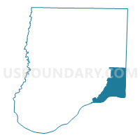
Outline

Summary
| Unique Area Identifier | 607310 |
| Name | Portland Voting District |
| County | Callaway County |
| State | Missouri |
| Area (square miles) | 47.09 |
| Land Area (square miles) | 45.45 |
| Water Area (square miles) | 1.64 |
| % of Land Area | 96.52 |
| % of Water Area | 3.48 |
| Latitude of the Internal Point | 38.76620140 |
| Longtitude of the Internal Point | -91.70314870 |
Maps


Graphs
Select a template below for downloading or customizing gragh for Portland Voting District, Callaway County, Missouri


Neighbors
Neighoring Voting District (by Name) Neighboring Voting District on the Map
- Big Spring/Americus Voting District, Montgomery County, MO
- Chamois Voting District, Osage County, MO
- Mineola Voting District, Montgomery County, MO
- Mokane Voting District, Callaway County, MO
- Readsville Voting District, Callaway County, MO
- Rhineland/McKittrick Voting District, Montgomery County, MO
- Williamsburg Voting District, Callaway County, MO
Top 10 Neighboring County Subdivision (by Population) Neighboring County Subdivision on the Map
- St. Aubert township, Callaway County, MO (1,969)
- Danville township, Montgomery County, MO (1,950)
- Loutre township, Montgomery County, MO (1,397)
- Benton township, Osage County, MO (1,172)
- Auxvasse township, Callaway County, MO (1,000)
- Nine Mile Prairie township, Callaway County, MO (790)
Top 10 Neighboring Unified School District (by Population) Neighboring Unified School District on the Map
- Gasconade County R-I School District, MO (7,671)
- South Callaway R-II Schools, MO (4,457)
- Osage County R-I School District, MO (1,156)
Top 10 Neighboring State Legislative District Lower Chamber (by Population) Neighboring State Legislative District Lower Chamber on the Map
- State House District 99, MO (42,788)
- State House District 20, MO (38,233)
- State House District 112, MO (34,350)
Top 10 Neighboring State Legislative District Upper Chamber (by Population) Neighboring State Legislative District Upper Chamber on the Map
Top 10 Neighboring 111th Congressional District (by Population) Neighboring 111th Congressional District on the Map
Top 10 Neighboring Census Tract (by Population) Neighboring Census Tract on the Map
- Census Tract 706, Callaway County, MO (6,426)
- Census Tract 702, Callaway County, MO (3,633)
- Census Tract 4901, Osage County, MO (3,381)
- Census Tract 9703, Montgomery County, MO (3,268)